


TransitLink How2Go

TransitLink How2Go의 설명
How2Go – Singapore Public Transport Journey Planner
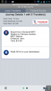
How2Go is a public transport app which provides reliable and accurate real time journey planning solutions*, giving optimized point-to-point route options and actual fares for all basic bus services, MRT and LRT.
Factoring in walking/waiting times and service frequencies, the solutions provided are based on
- Least number of Transfers
- Fastest Routes
In addition, users are able to customize their search using the advanced search feature which offers an extensive list of places of interest as preferred destination points.
---------------------------
Features include:
---------------------------
- User-friendly Interface.
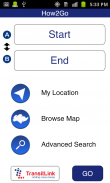
- Search using address, bus stop code, postal code, landmark, MRT / LRT station and road name.
- 'My Location' identifies user’s current location (GPS accuracy is dependent on user’s Smartphone**).
- ‘Bus Arrival Times’ provides users with the estimated arrival times of the next two buses of the selected bus service.
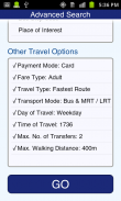
- 'Advanced Search' option allows users to customize their routes by selecting their preferred transport mode, payment, travel option, day and time of travel as well as specifying the fare type, maximum number of transfers, maximum walking distance, etc.
- Prompt user if the bus services have ended and provide suggested solutions for the following day, 0700 hours onwards.
- 'Browse Map' brings up the map of Singapore and clicking the 'Bus / MRT / LRT' icon will show the bus stops, MRT and LRT stations on the map.
- 'Places of Interest' (POI) gives a list of tourist attractions in Singapore.
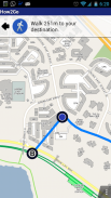
- 'Tools' allows user to shift 'Start' and 'End' markers to customize the origin and destination points on the map.
-------------------------
-Important Notes-
-------------------------
Trip Time (min):
- Estimated bus travel time includes walking time from/to a bus stop but is subjected to road traffic conditions.
- Estimated train travel time includes approximate walking time for transfer between MRT lines at Bishan, Buona Vista, DhobyGhaut, HarbourFront, Marina Bay, Outram Park, PayaLebar and Serangoon Stations.
- Include approximate waiting times of...
~ 3 minutes for transfer between Circle Line, North-East Line and North-South / East-West Line.
~ 2 minutes for transfer between MRT lines at City Hall, Raffles Place and Jurong East Stations
~ 6 minutes for transfer to Expo and Changi Airport Stations at Tanah Merah Station
~ 4 minutes for transfer between East and West Loops of Sengkang and Punggol LRT.
All bus rides specified are considered air-conditioned rides.
Fares for feeder, Townlink and Intra-Town bus services are capped at 3.2km.
Flat fare services such as NightRider, Nite Owl, Parks, Chinatown Direct, Services to Integrated Resorts and Premium Bus Services are not included in this version of How2Go (H2G).
----------------------
-Transfer Rules-
----------------------
1. Transfer time limit of 45 minutes.
2. All journeys must be within 2 hours of the first boarding on the same journey.
3. Single entry and exit allowed for rail.
4. Current bus service must not be the same number as the preceding bus service.
5. Maximum of 5 transfers (from the current) can be made within a journey.
Do feel free to give us your comments or suggestions on how we can improve this app!
Visithttp://www.transitlink.com.sgfor more information on How2Go.
Powered by TransitLink& V3TeletechHow2Go - 싱가포르 대중 교통 여행 플래너
How2Go는 모든 기본 버스 서비스, MRT와 LRT 최적화 된 포인트 투 포인트 경로 옵션 및 실제 요금을 제공, 정확하고 신뢰할 실시간 여행 계획 솔루션을 제공한다 * 대중 교통 응용 프로그램입니다.
시간 및 서비스 주파수를 산책 / 대기 감안가 제공하는 솔루션을 기반으로
- 전송의 최소 수
- 가장 빠른 경로
또한, 사용자가 선호하는 대상 지점으로 그 장소의 광범위한 목록을 제공하는 고급 검색 기능을 사용하여 검색을 사용자 정의 할 수 있습니다.
---------------------------
특징은 다음과 같습니다 :
---------------------------
- 사용자 친화적 인 인터페이스를 제공합니다.
- 주소 버스 정류장 번호, 우편 번호, 랜드 마크, MRT / LRT 역 및 도로 이름을 사용하여 검색.
- '내 위치'(GPS 정확도가 사용자의 스마트 폰 **에 따라 달라집니다) 사용자의 현재 위치를 식별합니다.
- '버스 도착 시간'을 선택한 버스의 다음 두 버스의 예상 도착 시간을 사용자에게 제공합니다.
- '고급 검색'옵션은 사용자가 선호하는 전송 모드, 지불, 여행, 옵션, 일, 여행뿐만 아니라 운임 유형을 지정 시간을 선택하여 자신의 경로를 교체의 최대 개수, 최대 도보 거리, 등등 사용자 정의 할 수 있습니다
- 신속한 사용자는 버스 서비스는 종료하고 다음 날을위한 솔루션, 0,700시간의 이후를 제안 제공합니다.
- 싱가포르의지도가 나타나고 아이콘이 버스는지도에서 MRT와 LRT 역을 중지 표시됩니다 '/ MRT / LRT 버스'를 클릭하면 '지도 검색'.
- '관광지'(POI)은 싱가포르 관광 명소의 목록을 제공합니다.
- '도구'는 사용자가지도에 출발지와 목적지의 지점을 사용자 정의 할 '시작'과 '끝'마커를 이동 할 수 있습니다.
-------------------------
- 중요 사항 -
-------------------------
여행 시간 (분)
- 예상 버스 여행 시간은 /에서 버스 정류장에서 시간을 걷는 포함되지만 도로 교통 상황에 노출되어 있습니다.
- 예상 기차 여행 시간은 비샨,오나 비스타 (Buona Vista), DhobyGhaut, 하버 프론트, 마리나 베이 (Marina Bay), 트램 파크, PayaLebar 및 랑군 역에서 MRT 라인 사이의 전송을위한 대략 걷는 시간을 포함합니다.
- 대략 대기 시간을 포함 ...
서클 라인, 노스 이스트 라인과 남북 / 동서 선 사이의 전송을 위해 2 ~ 3 분 거리에 있습니다.
시청 MRT 라인, 래플스 플레이스 및 주롱 이스트 역 사이의 이동을위한 ~ 이분
엑스포 타나 메라 (Tanah Merah) 역 창이 공항 역에 전송 ~ 육분
동쪽과 Sengkang 및 Punggol LRT의 웨스트 루프 사이의 전송을위한 1 ~ 4 분 거리에 있습니다.
지정된 모든 버스 타기는 에어컨 놀이기구 간주됩니다.
지류, Townlink과 내부 마을 버스 서비스에 대한 요금이 3.2를 넘지 않습니다.
같은 NightRider, 나이트 올빼미, 공원, 차이나 타운, 직접, 통합 리조트에 서비스 및 고급 버스 서비스 등의 정액 요금제 서비스는 How2Go (H2G)이 버전에 포함되지 않습니다.
----------------------
- 전송 규칙
----------------------
1. 사십오분의 제한 시간을 전송합니다.
2. 모든 여정은 동일한 여정의 첫 탑승 2 시간 이내 여야합니다.
3. 하나의 입구와 출구가 레일을 허용했다.
4. 현재 버스 서비스는 앞의 버스 번호와 동일 할 수 없습니다.
5. 5 전송 (현재의)의 최대 여행에서 만들 수 있습니다.
우리에게 우리가이 응용 프로그램을 개선 할 수있는 방법에 대한 귀하의 의견이나 제안을주고 자유롭게 느끼!
How2Go에 대한 자세한 내용은http://www.transitlink.com.sg하세요.
트랜짓 & V3Teletech에 의해 구동


